


A list member received this information: THE BRIGHT RED IS "OXIDIZED CIDER CONES, WHOSE COLORS WERE ENHANCED IN THE SATELLITE PHOTO" and I received this from Steven Brantley, U.S. Geological Survey: Lisa, You are quite mistaken about the interpretation of the image you found through Google Earth. Mauna Loa is not erupting at this time. The most recent eruption of Mauna Loa was March 25 through April 15, 1984. We have been working on Mauna Loa in the past week conducting an annual GPS survey, and no activity of any kind was observed by our field crews, including the crew working this morning. Fresh lava is not on the surface on the SW rift zone and it is not anomalously hot as you suggest in your email. The "red" material in the image is not lava; the red color is due to oxidized cinder erupted between about 500 and 1,000 years ago. The red color and the collage of satellite images stitched together with the clouds appearing to extend to the southeast looks like a plume (shape only, not the texture) but they are artifacts of the satellite images. Mauna Loa is very quiet at this time.
---- I have looked at images on Google Earth of Mauna Loa several times over the past year or two. About three weeks ago a friend of mine mentioned strange gases, noises and helicopters above the Hawaiian Ocean View Estates (H.O.V.E.) subdivision. I had heard these rumors before, so I spent several hours looking at Google Satellite images of Mauna Loa. I found no unusual buildings or activity on the volcano at any of these times. However, this time it was different. This week Tuesday, May 6, 2008, a farmer mentioned her Swiss Chard, Beets and young lettuce was burned by a mysterious ground hugging dark cloud that moved thru the fields of her farm including a small farm building. She was especially concerned that this gas burned her crops in ONE HOUR. She said the gas was not sulfur.. it had a very bad smell and she knew it was something different. She took samples of the burned chard, and swaps off her windows and had them tested by the state of Hawaii. They told her they could not find anything on the samples. As a gift to her, I printed off an aerial view of her farm in H.O.V.E. and gave it to her. As she left, I closed the browser.. but something red caught my eye, so I decide to check it out later. Back at my desk, and starting on Google Earth at H.O.V.E., I followed up the ridge and realized as I approached the summit of the Volcano that something was much different. Small red hot places doted the landscape. As I zoomed in for a closer look I realized, Google had updated their image and Mauna Loa appeared to be awakening. As you can see by the images above, these are not fuzzy images. These are very clear images showing what appears to be active lava breaking thru the black crust in multiple places. To help you understand this better, click on the link in BOLD below for the full image on google maps ... you can see there is a strange white cloud line on the left side of the image. (I have included a far image and a close up of the red LavaStar image above.) Google updated their image at the cloud line shown on this image. The clouds on the right are on the old image part that continues toward the summit and all looks fine. The darker image on the left half of this LavaStar image, is the new updated image.
BE SURE AND click here to see the image and scroll out and down along the ridge to see all the areas of bright red on the surface.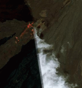
Many many people live under this volcano which has erupted 39 times since 1832 according to the USGS. In the past, during some of those eruptions, lava went from vent to ocean in less than 3 hours. People had LESS THAN 3 HOURS to get out of the lava's way.
History http://hvo.wr.usgs.gov/maunaloa/history/50_06_01/
Hazard Zones http://pubs.usgs.gov/gip/hazards/mauna-loa.html/
I am very concerned for those living in the path of the lava if Mauna Loa becomes active again, which it appears to be in this satellite image. An eruption is defined by "Lava on the surface" and in these images on Google Maps, we see what appears to be lava on the surface in different locations, including some down the side slopes.
Hawaii island is also under a very heavy Vog Alert, (volcanic smog) which we are told is coming from Kilauea Volcano, which is also located on this island. Vog can cause burning of the throat and breathing problems.
Vog has destroyed some local crops including some in the H.O.V.E. community, which is one of the largest subdivisions ever built at 11,500 acres and sits at the southern edge of the SW Rift Zone of Mauna Loa. Yes, one of the largest subdivisions ever built, is straddling the SW Rift Zone of the Mauna Loa Volcano. The people in H.O.V.E. would have even less time to be evacuated, if that became necessary.
I have emailed, visited and/or called the police, fire, civil defense, four local TV news stations, newspapers, locally and nationally over the past 2 days. I have sent the link above and my list mail to more than 3000 people including NOAA, USGS and other agencies with no word from them or anyone, except from my list members who were also very concerned and forwarded me information. (I finally heard something back after emailing the information directly to Steve Brantley.. see his quote above.)
My list mail is archived here: http://www.angelsfortruth.com/blog/?p=120/
If the google images are somehow wrong I could understand that, but no one had even has even addressed that as an issue.... until now.
As you can see by the quote at the top of this page, the issue was addressed that the OXIDIZED CIDER CONES COLORS might have gotten enhanced somehow.
I have spent additional hours comparing older satellite images with newer images. See this link for older images of LavaStar and a before and after of two Craters on the Rim along with many other comparisons: http://www.angelsfortruth.com/blog/?p=132/
I am still not totally convinced that nothing is happening up there, but I can see that the color on the images does look similar to the color in older images of the volcano, only very much brighter and denser in intensity as seen in the images at the link above.
I am sorry if I frightened anyone unnecessarily, my intent is always to find and spread the truth and nothing else.
(Note: You can view every article as one long page if you sign up as an Advocate Member, or higher).


