Today's Guardian, includes an article, Revealed: the secret evidence of global warming Bush tried to hide
It reports that he Obama administration has declassified about 1000 spy satellite images that dramatically show the effects of global warming.
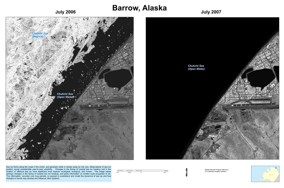
Satellite images of polar ice sheets taken in July 2006 and July 2007 showing the retreating ice during the summer. Photograph: Public Domain
The Guardian article reports:
One particularly striking set of images - selected from the 1,000 photographs released - includes views of the Alaskan port of Barrow. One, taken in July 2006, shows sea ice still nestling close to the shore. A second image shows that by the following July the coastal waters were entirely ice-free.
The photographs demonstrate starkly how global warming is changing the Arctic. More than a million square kilometres of sea ice - a record loss - were missing in the summer of 2007 compared with the previous year.
Nor has this loss shown any sign of recovery. Ice cover for 2008 was almost as bad as for 2007, and this year levels look equally sparse.
"These are one-metre resolution images, which give you a big picture of the summertime Arctic," said Thorsten Markus of Nasa's Goddard Space Flight Centre. "This is the main reason why we are so thrilled about it. One-metre resolution is the dimension that's been missing."
The problem is, according to Jane Lubchenco, Head of National Oceanic and Atmospheric Administration (NOAA), funding for satellite resources for studying and continuing the monitoring of climate change geography has diminished.
Not surprisingly, the Bush admin's philosophy was, if you don't know about it, it's not a problem.
Rob Kall is an award winning journalist, inventor, software architect,
connector and visionary. His work and his writing have been featured in the New York Times, the Wall Street Journal, CNN, ABC, the HuffingtonPost, Success, Discover and other media.
Check out his platform at RobKall.com
He is the author of The Bottom-up Revolution; Mastering the Emerging World of Connectivity
He's given talks and workshops to Fortune
500 execs and national medical and psychological organizations, and pioneered
first-of-their-kind conferences in Positive Psychology, Brain Science and
Story. He hosts some of the world's smartest, most interesting and powerful
people on his Bottom Up Radio Show,
and founded and publishes one of the top Google- ranked progressive news and
opinion sites, OpEdNews.com
more detailed bio:
Rob Kall has spent his adult life as an awakener and empowerer-- first in the field of biofeedback, inventing products, developing software and a music recording label, MuPsych, within the company he founded in 1978-- Futurehealth, and founding, organizing and running 3 conferences: Winter Brain, on Neurofeedback and consciousness, Optimal Functioning and Positive Psychology (a pioneer in the field of Positive Psychology, first presenting workshops on it in 1985) and Storycon Summit Meeting on the Art Science and Application of Story-- each the first of their kind. Then, when he found the process of raising people's consciousness (more...)