

(To read Part 1, click here)
(To read Part 2, click here)
Sunday morning, October 12, Houma, Louisiana:
I have been experiencing the Voice of the Wetlands Festival for the last two days, enjoying the music and learning more about the ecology of the wetlands. But now my wife and I have to cut short our visit, even though the festival will resume at Noon, and head on back to New Orleans International Airport to catch a mid-afternoon flight. But the plight of southern Louisiana has not been lost on me, nor hopefully, on you, the reader.
The wetlands of Louisiana are being destroyed by 1) blocking off the annual sediment deposits from the Mississippi River, 2) the building of endless canals crisscrossing the southern Louisiana wetlands that then invite the insidious spread of destructive saltwater intrusion, and of course, 3) by contractors being allowed to bulldoze, fill in and pave the wetlands in the interests of commercial development. But there is another factor that also affects, not only the wetlands, but all the waterways - rivers, lakes, bayous, etc., and that is urban, industrial and agricultural pollution of these waterways. This became clear to me as I was driving back from the festival this Sunday morning.
As we were leaving the outskirts of Houma, first I was able to get a good look at one of the many canals dredged out in Louisiana, canals that have become part of the environmental problem. This one was running under Floyd Duplantis Bridge below:
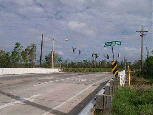
Here is the canal itself:
. Note the large pipes running down into the water. I assume they are suction and discharge pipes connected to a pumping station just to the right in what I guess you can call a spill-over pond, or even secondary canal, because it runs parallel to the first canal as far as the horizon, as you will see in the second photo after the one of the pumping station directly below:
. Note the pollution and heavy surface vegetation that suggests water deterioration, even toxicity.
Looking south at this same "spill" canal, if I can technically call it that, you see that this thick film of aquatic vegetation coats the entire surface, suggesting a stagnant, perhaps even putrid body of eutrophic water. What happens when storms and hurricanes cause this canal to, in turn, exceed its boundaries and flood over the land, soaking into the soil, or even into other bodies of water?
(Note: You can view every article as one long page if you sign up as an Advocate Member, or higher).


