Bayou Corne Sinkhole 10.11.12
(Image by Photo by Jeffrey Dubinsky, flight by Southwings) Details DMCA
Background: Last Spring Louisiana's Corne and Grand Bayou residents noticed strange bubblings in the bayou for many weeks, and they reported smelling burnt diesel fuel and sulfur. Then suddenly a sinkhole the size of three football fields appeared on Aug. 3, swallowing scores of 100-foot tall cypress trees. The sinkhole resulted from the failure of an abandoned underground brine cavern. The Department of Natural Resources issued a Declaration of Emergency on Aug. 6, and 150 families were evacuated. For maps, diagrams and additional information, see the previous articles in this series:
Mysterious Bayou Sinkhole Continues to Cave In: Radiation, Hydrocarbons Detected at click here
Dangerous Levels of Radium at Corne Bayou Sinkhole at click here
Does Sudden Sinkhole Portend a Nuclear-sized Explosion? at click here
Napoleonville, LA.
The treacherous sinkhole that first appeared on Aug. 4 in Bayou Corne continues to cave in. On Oct 30, a 20-ft by 80-ft section caved in on the east side of the sinkhole, just a week after a "short duration, pronounced seismic event was recorded at the site."
This map dated Oct 14 shows the most recent dimensions of the sinkhole before the 1600-square-ft cave-in on Oct. 30.
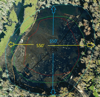
Sinkhole Dimension Map Oct. 14, 2012
(Image by Assumption Parish Police Jury, used with permission) Details DMCA
Compare to this map, which shows the dimensions of the sinkhole on Sept 21 (gold outer line. The purple inner line shows the dimensions of the original sinkhole on Aug 4.) Dimensions have increased from about 410 ft by 480 ft, to 550 ft by 550 ft, before the most recent cave-in.
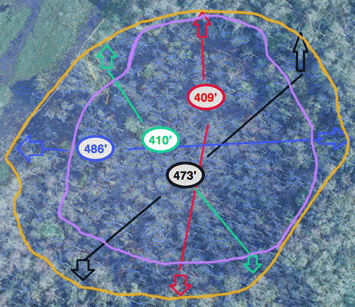
Growth of the Bayou Corne Sinkhole (outlines & dimensions bolded for visibility)
(Image by Assumption Parish Office of Homeland Security & Emergency Preparedness) Details DMCA
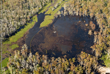
Compare this image of the sinkhole dated Oct. 11 ...
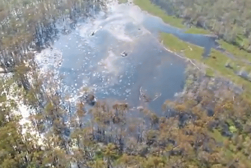
Sinkhole (Oct 11 Flyover)
(Image by Assumption Parish Police Jury, used with permission) Details DMCA
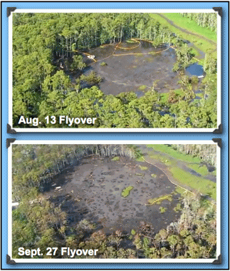
...with these earlier images, from approximately the same perspective:
and this, the most current image available, from the flyover on Oct. 29, (taken before the huge cave-in on Oct. 30):
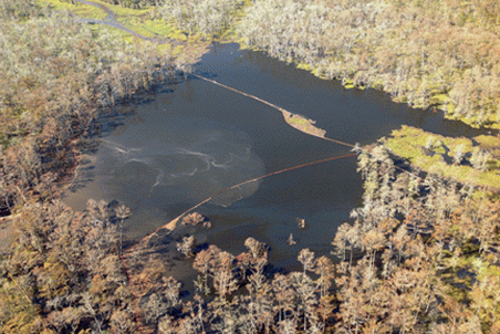
Sinkhole Growth Oct. 29, 2012
(Image by Assumption Parish Police Jury, used with permission) Details DMCA
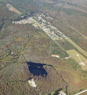
This photo, also from the flyover on Oct. 29, shows the sinkhole in relationship to the nearby community.
In a post on Oct. 12, the Louisiana Environmental Action Network (LEAN) noted: "(On) October 11, 2012, photographer Jeffrey Dubinsky took a flight for LEAN and LMRK over the Bayou Corne sinkhole. After the flight, which was generously provided by Southwings, Jeffrey commented on the intense petroleum fumes experienced while flying over the sinkhole area:
'I will say the odor was the heaviest and strongest I have ever experienced in all my time in Louisiana. Perhaps even worse still was that the odor was hovering directly over the community... I have no idea whatsoever how the workers can tolerate being anywhere near it.'
LEAN continues, "There is no doubt that the fumes from the sinkhole and bubbling natural gas in the surrounding area have been impacting the community. Local residents have documented this along with their potentially related health symptoms."
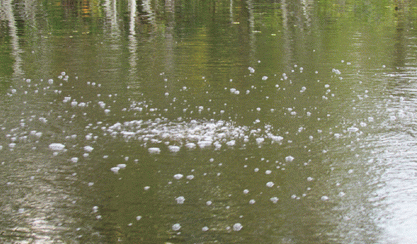
Bubbling site near pipeline in Bayou Corne. 09.16.12
(Image by Assumption Parish Police Jury Photostream (used with permission)) Details DMCA
LEAN has been conducting an odor and symptom data collection.(click here)
Description of odors include the smell of diesel, tar, gas and the smell of burning trees. LEAN notes that 84% of individuals reporting odors, experienced health impacts associated with the odor events, including headache, sore throat, nose irritation, burning and watery eyes, and fatigue.
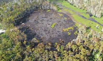
Bayou Corne Sinkhole Sept. 27, 2012.
(Image by Assumption Parish Police Jury (used with permission)) Details DMCA
On Oct 11, "Louisiana Commissioner of Conservation James Welsh ... ordered Texas Brine LLC to take action to assess and abate threats to public safety and the environment caused by the failure of its abandoned brine cavern on the west side of the Napoleonville Salt Dome, including the presence of natural gas in the area ground water aquifer," according to a press release from the Louisiana Department of Natural Resources. "Welsh noted that, based on 'fingerprint' analysis and other data, the source of the crude oil and natural gas that have been observed at the surface in the Bayou Corne area appears to be one or more naturally occurring oil and natural gas formations, and that the preponderance of scientific evidence indicates that the failure of the sidewall of the Texas Brine cavern provided a pathway up to the aquifer and the surface for oil and natural gas that had previously been confined thousands of feet below." click here
Wilma Subra of the Subra Company lists these additional cave-ins in her article, Sampling Continues at Bayou Corne as Sinkhole Expands, (click here):
September 20, 2012: Approximately 25' of embankment on the east side fell into the sinkhole.
September 18, 2012: Texas Brine reported a slough-in of approximately 200' of embankment at the sinkhole.
September 17, 2012: Texas Brine reported a 20' x 20' growth of the sinkhole."
ADDED NOV 1, 2012:
This image of the cave-in on Oct 30 was made available on Oct. 31 by the Assumption Parish Police Jury. The red line has been thickened for readability.
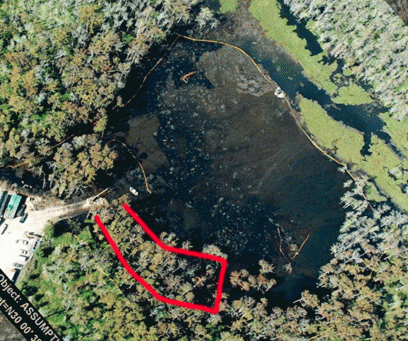
Map of Oct. 30, 2012 cave-in (Map released on Oct 31)
(Image by Assumption Parish Police Jury (used with permission)) Details DMCA
Wilma Subra, is a scientist and Pres. of the Subra Company, and past Vice-Chair of the Environmental Protection Agency National Advisory Council for Environmental Policy and Technology (NACEPT). Her company provides technical assistance to citizens concerned with environmental issues, by combining technical research and evaluation.


