

Along the Gulf Coast, Post Katrina, Part 3: Orleans Avenue, New Orleans
On Friday, April 13, 2007, after surveying hurricane damage in Ocean Springs, Mississippi, I high-tailed it up to Interstate 10 and headed due west. An hour plus later I was passing the state line into Louisiana and soon bearing down on Slidell as I-10 gradually curved south. Even before Slidell I began to get glimpses of Katrina's wrath out of the corners of my eyes as I sped on - torn up trees, piles of debris or damaged buildings in the distance. By time I had passed Slidell and was hitting the Huey P. Long Bridge, all kinds of questions were percolating in my head – how many towns and cities were hard-hit, how many people displaced; how much had been repaired; what have been the overall costs? And on and on.
As I drove over Lake Pontchartrain and gradually began the downward descent on the southern end of the bridge, the image of the far shore rising out of the vast blue lake waters rammed home to me just how fragile and isolated New Orleans is, and how low. You gained the distinct impression as you reached shore again that you were almost dropping into the lake, and in a sense you are, because, of course, the Crescent City is actually below sea level. And when you realize how the city and parish are bordered on the north by the lake, and east and south by the Gulf of Mexico, that is vulnerable indeed.
At last the skyscrapers of downtown New Orleans began looming into view, introducing some verticality into the geography, as if that was somehow reassuring as the next hurricane season approaches. I was getting more excited now, because I hadn't been to New Orleans since 1979, when I was on leave from the military, and had truly missed the place, which I had found magical and romantic.
Finally, I slowed down and began signaling left to take the exit for Vieux Carré (Old Square), the original French term for the French Quarter. Down I went, until the off-ramp suddenly drops you right onto Orleans Avenue, which runs parallel to better known Canal Street, which takes you smack into the French Quarter. But I had flown in here before, not driven, so I was disoriented. Should I turn left or right? My instincts told me the French Quarter was to the left and what I was really interested in was to the right, because I hadn't come down here to party, but to investigate the aftermath of Katrina. So I turned right.
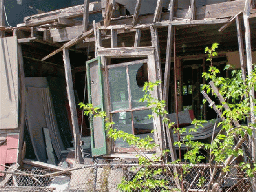
A fortuitous decision. I hadn't driven two blocks before I was muttering Jesus under my breath. And I hadn't driven but several more before I was parking the car and grabbing my camera. My worst fears were materializing, based upon reports I had read, that the Polyanna depictions of New Orleans on the mend were greatly exaggerated. Now reality was staring me in the face, an entire, devastated neighborhood pretty much left to its own devices, as well as actually sabotaged, I would learn over time, from full recovery by the powers that be.
Next Page 1 | 2 | 3 | 4 | 5 | 6
(Note: You can view every article as one long page if you sign up as an Advocate Member, or higher).


